
Google Maps Adds The International Space Station

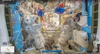 Image copyright
Google
Image copyright
Google
The International Space Station has become the first "off planet" addition to Google Maps' Street View facility.
Astronauts helped capture 360-degree panoramas of the insides of the ISS modules, as well as views down to the Earth below.
Some of the photography features pop-up text descriptions, marking the first time such annotations have appeared on the Maps platform.
This is not the first time 360-degree imagery has been captured beyond Earth.
In 2015, the European Space Agency published its own interactive tour of the ISS. And last year Nasa repurposed images captured by its Pathfinder mission to Mars to create clips suitable for virtual reality headsets.
However, one of the benefits of Google's technology is that it should give members of the public an improved sense of freedom of movement and a greater choice of viewpoints than had been possible before.
The tech giant said it hoped to inspire the public to further explore the science and engineering involved in space exploration.
"Every [ISS] component had to be flown on a space shuttle or rocket and constructed and connected in space, and it had to be done with such precision that it formed a hermetic environment to support life," project manager Alice Liu told the BBC.
"That is an engineering marvel that people should care about and know about."
Bungee cords
The firm said creating the latest Street View expansion had posed unique challenges.
Past efforts - including capturing underwater views of Australia's Great Barrier Reef and elevated sights from Peru's Machu Picchu citadel - involved transporting specialist camera equipment to the locations.
But the cost and certification processes that would have been required to do this for the ISS meant it was not practical this time, nor could the US company send its own staff to take the photographs.
Instead, it had to rely on the astronauts already on board the ISS, who used digital single lens reflex (DSLR) cameras they already had to hand.
"Typically, to stitch panoramic images we take a camera and mount it on a fixed mount and rotate it around," explained Ms Liu.
"In space there were no tripods, so we ended up using a really simple set-up: a pair of bungee cords strapped in the module in a criss-cross fashion, so that the crossing point defined the centre of where the camera needed to be.
"The astronauts had to take the pictures at the defined angles and float around the camera to complete the set of images."
It took up to 24 such images to create a single panorama.
The astronauts had to fit the activity round their other duties and, from first snap to last image download to Google, the initiative lasted four months.
"There are a lot of obstacles up there, and we had limited time to capture the imagery," recalled astronaut Thomas Pesquet in a blog.
"Oh, and there's that whole zero gravity thing."
The notes that pop up as the user moves among the station's 15 modules provide background information about the equipment on display, and are intended to help make sense of what Google acknowledges can be a "confusing" experience.
Ms Liu confirmed the annotation technology could be rolled out to some of her firm's other Street View locations in the future.
"But we are not planning on using it as a form of advertising," she added.
While the ISS tour might not provide Google the opportunity to make money in itself, one expert suggested it would help the firm keep its mapping products one step ahead of Apple and other rivals.
"This feels like a cute marketing exercise that will keep Maps and Street View front and centre in consumers' minds," commented Ben Wood from the CCS tech consultancy.
"It adds a dimension of fun and one could argue also education, as it's a tool you could see schools adopting if they are doing projects on space."
From Chip War To Cloud War: The Next Frontier In Global Tech Competition
The global chip war, characterized by intense competition among nations and corporations for supremacy in semiconductor ... Read more
The High Stakes Of Tech Regulation: Security Risks And Market Dynamics
The influence of tech giants in the global economy continues to grow, raising crucial questions about how to balance sec... Read more
The Tyranny Of Instagram Interiors: Why It's Time To Break Free From Algorithm-Driven Aesthetics
Instagram has become a dominant force in shaping interior design trends, offering a seemingly endless stream of inspirat... Read more
The Data Crunch In AI: Strategies For Sustainability
Exploring solutions to the imminent exhaustion of internet data for AI training.As the artificial intelligence (AI) indu... Read more
Google Abandons Four-Year Effort To Remove Cookies From Chrome Browser
After four years of dedicated effort, Google has decided to abandon its plan to remove third-party cookies from its Chro... Read more
LinkedIn Embraces AI And Gamification To Drive User Engagement And Revenue
In an effort to tackle slowing revenue growth and enhance user engagement, LinkedIn is turning to artificial intelligenc... Read more